It was an early start for our drive to Aoraki/ Mt Cook and the prospects of it being a clear day weren't looking good as there was still a lot of the low lying cloud hanging around from the previous, but we thought we should persevere as the weather forecast for the following day wasn't much better. The reason why it's important for us to see Aoraki/ Mt Cook was that we never got to see it first time round in New Zealand and it's also the highest peak in Australasia at 3,754m (however, I think this depends on the political definition of Australasia as Mt Wilhelm in Papua New Guinea is higher at 4,509m).
Driving out along State Highway 8, southwest towards Twizel we eventually reached Lake Pukaki, which is similar to
Lake Takepo, in that its a glacier fed lake (sourced by the Tasman River) with pale-turquoise-blue water due to the "rock flour" suspended in the lake. At one point we were up so high in the mountains that we were driving through the clouds along the lakeside. Stopping off at the southern shore we tried to take some photos north towards Aoraki/ Mt Cook but the tops of the mountains were still hidden among the clouds - we weren't even sure if we were going to see the top of Mt Cook at all today....
 |
| It is possible to see Mt Cook 70km north from here, but not today... |
 |
| Somewhere behind the bank of clouds is the Ben Ohau Range |
Trying not to get too disheartened by the weather, we continued along State Highway 80 (Mount Cook Road) to get to Aoraki/Mt Cook National Park, driving along the opposite side of Lake Pukaki. Before we knew it we reached a sea of white, but this wasn't snow - it was a flock of sheep! I wondered at what point we might come across a flock on our travels as I would have been disappointed not to have seen any in the rural areas!
 |
| A small number of New Zealand's 40 million sheep! |
 |
| Insert your own sheep joke here or a "ewe-phemism"! Boom! |
 |
| The sheep didn't want to stick around as the puns were so "baaad"! |
The closer we got to Aoraki/Mt Cook the clearer the skies got and it seemed for once that our perseverance was going to pay off! Arriving in Aoraki/ Mt Cook village we noticed that the Hooker Valley and Tasman Valley roads were closed so we decided to get some more information at the
Department of Conservation visitor centre. The visitor centre was very impressive as it had lots of informative displays and exhibits, as well as weather information and advice on walks and activities in the national park. Aoraki/ Mt Cook National Park is part of the
Southwest New Zealand World Heritage Area (Te Wāhipounamu - the place of greenstone). Of the 27 mountains over 3,050m in New Zealand, 19 of them are in this park.
Known as Aoraki to the Māori, or "Cloud Piercer" after an ancestral diety in Māori mythology, Mt Cook itself is more of a range of unimaginatively named peaks with the highest point being High Peak at 3,754m followed by Middle Peak at 3,742m and then Low Peak at 3,595m .
 |
| The visitor centre gives a spectacular axial view of Aoraki/ Mt Cook |
 |
| Stained glass window looking out towards the Sealy Range
|
We had hoped to do the Blue Lakes and Tasman Glacier View trail, plus the Hooker Valley Track, however due to road closures (because of snow) we would have had to walk back out to the Tasman Valley road from the village and a further 8 km to the start of the track, so we opted to do just the Hooker Valley Track (roughly 2 hours one way) and if we had time the Kea Point Track (1 hour one way) as well, which was along the way.
 |
| In the top right hand corner of the shot is Aoraki/ Mt Cook, 6.5km in the distance
|
 |
| The view looking back in the direction of the village |
 |
| The ice crystals on the ground were absolutely huge |
Deciding to do the Hooker Valley Track first as it's one of the most popular walks in the national park, we started off from the centre of the village walking the past the famous alpine hotel, The Hermitage. There's a bronze statue of a youthful Sir Edmund Hillary looking outwards to Aoraki/ Mt Cook, where he first climbed the South Ridge in 1948. Following the track past White Horse Hill campsite, Lizzie stumbled upon "
Freda's Rock", which was the rock where self-taught Australian climber Freda du Faur posed for a photo whilst on her way to becoming the first woman to reach the summit of Aoraki/ Mt Cook on 3
rd December 1910 with local guides Alec and Peter Graham
. Their venture was the second successful ascent of the west ridge of Aoraki/ Mt Cook and was completed in a record time of 14 hours return – this not only made Freda the first female to reach the peak of New Zealand’s tallest mountain, but also the first Australian!
 |
| Lizzie posing at Freda's Rock |
.jpg) |
| The first woman to conquer Mt Cook |
The photo of Emmeline Freda du Faur by George Edward Mannering is a New Zealand work available in the public domain.
A little further along the path we reached the
Alpine Memorial, which serves as a poignant reminder of how dangerous the mountains can be. There were numerous plaques in memory to people of all ages, nationalities and gender. The youngest person on the memorial was 18 years old and the most recent death was back in 2004.
 |
| Many climbers have lost their lives in Aoraki/ Mount Cook National Park |
 |
| The memorial serves as a great viewpoint to Mt Cook, a fitting tribute |
When we reached the Mueller Lake viewpoint we can could see three smaller glaciers on the
Main Divide: the Huddleston Glacier, Stocking Glacier (Te Waewae) and obviously the Mueller Glacier.
It was here that we also reached our first swing bridge of the walk, although I couldn't figure out why it was called that as it looked more like a suspension bridge made of wood and steel cables, however, it didn't half sway as we crossed over the turbulent Hooker River.
 |
| The first swing bridge of the walk above the icy Hooker River |
 |
| Lizzie at the other end of the swing bridge with the Sealy Range behind |
Making our way northeast through the valley above the frozen Mueller Lake, it was so calm and silent you could hear the ice creaking and cracking as it was slowly moving in the lake below - it was quite an eerie experience especially when we hadn't seen anyone else on the walk.
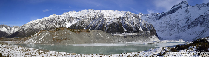 |
| A panoramic view of the Mueller Glacier, Hooker River and moraine - click here to view in hi-res
|
Continuing on the track there was a distant rumbling sound in the mountains like a stampede down a hill and before we knew it there was a small avalanche taking place on the top of Mt Sefton! It was quite exciting and scary at the same time as we weren't expecting anything like that to happen through the valley. It wasn't as dramatic as it sounds but it did put us on edge for a little while.
 |
| AV-A-LANCHE!! |
Just before the second swing bridge, there were a couple of warning signs saying that the bluff section before the second bridge was icy and had dangerous drop offs! What we hadn't appreciated was how icy the path had become, and a couple of times we had to hold onto the hand rail with both hands just to pull ourselves up the stone steps without stopping in case of falling rocks! Lizzie wasn't impressed by this part of the trail but I don't think it was as bad as it looked - I thought the rickety second swing bridge was much worse...
 |
| There's a small warning on a sheet of paper about the icy bluff ahead! |
 |
| No stopping for photos round the bluff
|
 |
| You can just about make out the hand rail keeping us from the river below |
Shortly after crossing the second swing bridge we lost the path down by the river as all we could see were icy boulders. The DOC leaflet we picked up (
Walks around Aoraki/ Mount Cook village) wasn't much help as it was a bit light on content and the map wasn't detailed enough - I guess the track at this point is more obvious during the summer.
 |
| Where do we go now? |
 |
| Wind blowing snow off the peak of Mt Sefton |
We were meant to continue beside the river but after quite a lot deliberating we found some stepping stones and the track became clear to us once again. Crossing over the frozen Stocking Stream to the shelter, it was another half an hour before we reached the terminal face of the glacier but when we reached the Hooker Lake it was a sight to behold. We were able to walk right up from the frozen lake edge 900m above sea level, looking up at the glacier and towards the peak of Aoraki/Mt Cook.
 |
| Avalanche warning? I laugh in the face of danger! |
 |
| The Hooker Glacier approx. 11km in length (6-7 miles) |
 |
| Reflections in the frozen Hooker Lake |
 |
| The upper sections of the Hooker Glacier |
Edging as close to the terminal face as possible, we walked under a pretty steep slope with some precarious looking rocks. You also could hear the sheets of ice splintering by the lake edge and the occasional distant groaning noise which I reckon was from the glacier but it was really creepy and we decided it was a good time to head back to the village - it was wilderness at it's best as we'd only seen three people on the whole walk!
 |
| By far the most impressive thing we've seen in New Zealand! |
 |
| Down at the terminal face of the Hooker Glacier |
 |
| Walking back towards the swing bridge |
On the way back to the village we saw another avalanche off Mt Sefton but this time we were on the icy bluff after the swing bridge so I didn't have an opportunity to stop and take photos. By the time we reached the point where the Kea Point Track started, we decided not to bother as we had spent quite a lot of time on the Hooker Valley Track and we felt that Mueller Glacier wasn't that impressive - we weren't even sure if we had seen it...
 |
| Quite literally the indomitable face of Mt Cook
|
 |
| The opposite end of Lake Pukaki from the Hooker Valley |
On the whole, it was a much better day than we could have imagined, although possibly not the safest way to enjoy seeing Aoraki/ Mt Cook. The track in particular was really icy on large parts of the walk and it wouldn't have gone amiss to have worn crampons on certain parts, especially on the bluff when we walked above the river towards the second swing bridge. Well at least survived the walk without falling flat on our arses!
 |
| Light-playing on the mountains during sunset |


No comments:
Post a Comment